Precision Irrigation: The Role of GPS Mapping in Installation Processes
In the realm of modern agriculture, efficiency isn’t just a goal—it’s a necessity. With the pressing challenges of climate change and water scarcity, agricultural businesses are increasingly turning to advanced technologies for solutions. Among these technological marvels stands precision irrigation, a method that promises to transform farming practices by conserving resources while maximizing yield. Central to this transformation is the use of GPS mapping in irrigation installation processes.
This blog post aims to explore how GPS mapping plays a pivotal role in precision irrigation, offering agricultural businesses insights into how they can leverage this technology to optimize water usage and enhance crop productivity. You’ll discover what precision irrigation entails, how GPS mapping integrates into the process, and why Western Irrigation is a leader in this field.
Understanding GPS Mapping in Irrigation Installation
- What is GPS Mapping? GPS mapping is a technology that uses satellite signals to determine precise locations on Earth’s surface. In agriculture, it’s used to create detailed maps of fields that include topography, soil types, and water distribution needs. This information guides the design and installation of irrigation systems, ensuring they are tailored to the specific needs of each plot of land.
- How Does It Work? GPS mapping works by using satellite signals to pinpoint locations with remarkable accuracy. These signals are received by devices on the ground, which then process the data to create detailed maps. For irrigation, these maps help identify the best locations for pipelines, sprinklers, and drip systems, ensuring efficient water distribution.
- Types of GPS Mapping Systems: There are several types of GPS mapping systems, each with its own set of features. Some systems offer real-time data processing, allowing farmers to make immediate adjustments to their irrigation systems. Others provide comprehensive soil analysis and topographical mapping, essential for designing efficient irrigation layouts. Choosing the right system depends on the specific needs and scale of your agricultural operation.
- Comparison with Traditional Installation Methods: Traditional irrigation installations often rely on manual measurements and estimations, which can lead to inaccuracies and inefficiencies. GPS mapping, conversely, offers precise data that eliminates guesswork. This precision not only leads to better water management but also reduces installation time and costs, making it a superior choice for modern agriculture.
The Role of GPS Mapping in Precision Irrigation
- Explanation of GPS Mapping Technology: GPS mapping technology acts as the backbone of precision irrigation, providing the foundational data needed to tailor water delivery systems to the nuances of a field’s landscape. This technology allows for the creation of detailed spatial maps that highlight variations in soil types, elevation changes, and other critical factors affecting irrigation.
- Benefits of Using GPS in Irrigation Processes: Integrating GPS mapping into irrigation processes offers numerous benefits. It increases accuracy in water application, ensuring that each plant receives the optimal amount of water. This precision reduces waste and enhances water conservation, leading to cost savings and environmental benefits. Additionally, GPS mapping facilitates more efficient farm management by providing real-time data that supports informed decision-making.
- Integration with Precision Agriculture: GPS mapping is not just limited to irrigation; it plays a crucial role in the broader scope of precision agriculture. By combining GPS data with other technologies such as remote sensing and variable rate technology, farmers can create comprehensive management plans that optimize resources, increase productivity, and improve sustainability outcomes.
Advantages of Using GPS Mapping for Installation Processes
- Increased Accuracy: GPS mapping brings an unprecedented level of accuracy to irrigation installation. By using detailed geographic data, irrigation systems can be precisely mapped out, ensuring water reaches exactly where it’s needed. This accuracy reduces the risk of overwatering or underwatering, leading to better crop outcomes.
- Time and Cost Savings: Installing irrigation systems traditionally can be time-consuming and costly. With GPS mapping, these processes are streamlined, reducing the time and resources required for installation. The technology eliminates the guesswork, leading to faster setup times and cost-effective implementation.
- Improved Efficiency: Efficiency is at the heart of precision irrigation, and GPS mapping plays a crucial role in achieving it. The technology ensures that water is applied evenly across fields, maximizing resource use and enhancing crop yields. Farmers can expect lower operational costs and higher returns on investment.
- Reduction in Water Usage: One of the most significant advantages of GPS mapping in irrigation is its ability to reduce water usage. By targeting water application precisely, farmers can conserve this precious resource, supporting sustainable farming practices and contributing to environmental conservation efforts.
The Process of GPS Mapping in Irrigation Systems
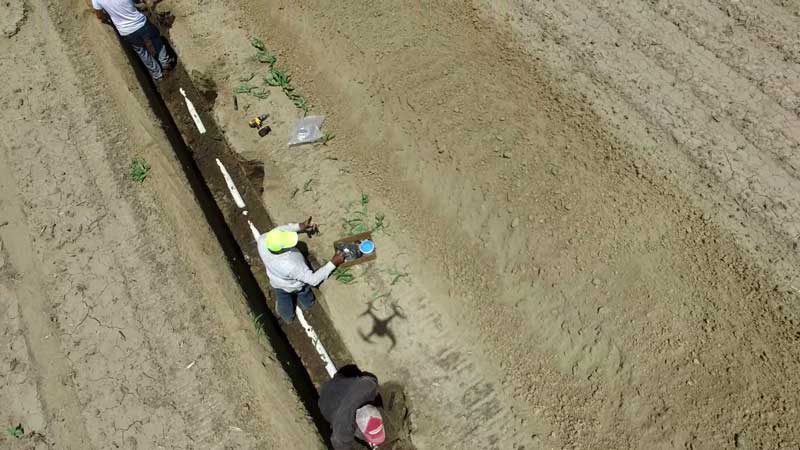
- Initial Site Assessment: Before any installation begins, an initial site assessment is conducted. This assessment involves analyzing land features, soil types, and other relevant factors. GPS mapping tools are used to gather data, providing a detailed understanding of the field’s characteristics and informing the irrigation design process.
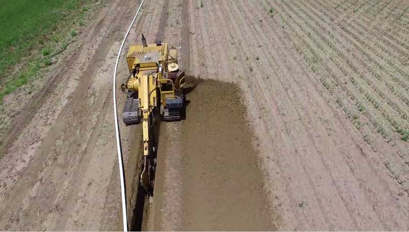
- Mapping the Field Using GPS Technology: Mapping the field involves using specialized GPS equipment and software to create detailed maps of the terrain. These tools capture essential data points, such as elevation changes and slope gradients, which are critical for designing effective irrigation systems. The mapping process ensures that every aspect of the field is considered in the irrigation layout.
- Interpreting GPS Data to Design the Ideal Irrigation Layout: Once the mapping data is collected, it is interpreted to design an irrigation layout tailored to the field’s specific needs. Advanced software is used to model various scenarios, optimizing the placement of irrigation lines, sprinklers, and other components. This design process ensures that the system delivers water efficiently and effectively.
Western Irrigation’s Approach
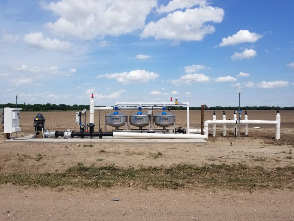
- Overview of Western Irrigation’s Services: Western Irrigation is a leader in precision irrigation, offering a range of services designed to optimize water use and enhance crop production. Their team of experts provides comprehensive solutions, from initial site assessments to GPS mapping and irrigation system design. With a focus on sustainability and efficiency, Western Irrigation helps farmers achieve their goals while conserving valuable resources.
- How GPS Mapping is Incorporated Into Their Installations: At Western Irrigation, GPS mapping is an integral part of the installation process. By leveraging advanced mapping technology, they ensure that each irrigation system is tailored to the specific needs of the land. This precision leads to improved water use efficiency, reduced costs, and enhanced crop yields, making Western Irrigation a trusted partner for agricultural businesses.
- Benefits for Farmers and Growers: Farmers and growers who work with Western Irrigation benefit from a range of advantages, including increased efficiency, reduced water usage, and improved crop health. By incorporating GPS mapping into their installations, Western Irrigation helps farmers achieve their sustainability goals while maximizing productivity and profitability.
How Western Irrigation’s Services Enhance Water Efficiency
- Utilizing Field Data to Optimize Irrigation Schedules: Western Irrigation uses data collected through GPS mapping to develop optimized irrigation schedules. This approach ensures that water is delivered at the right time and in the right amounts, reducing waste and supporting healthy crop growth. The result is a more efficient use of water resources and better overall productivity.
- Precision Control of Water Application: With Western Irrigation’s services, farmers can achieve precision control over water application. The company’s systems are designed to deliver water exactly where it’s needed, ensuring that no area is over or under-watered. This precision supports optimal plant health and growth, leading to higher yields.
- Reducing Water Loss and Waste: Water loss and waste are significant concerns in agriculture, but Western Irrigation’s solutions address these issues head-on. By using GPS mapping and precision irrigation techniques, the company helps farmers conserve water and minimize waste. This approach supports sustainable farming practices and promotes long-term environmental health.
The Future of Precision Irrigation and GPS Mapping
- Advancements in GPS Mapping Technology: The future of precision irrigation is closely tied to advancements in GPS mapping technology. Ongoing developments in satellite imagery, data analytics, and machine learning are poised to enhance the accuracy and effectiveness of GPS mapping systems, further optimizing irrigation practices.
- Potential Impact on Precision Irrigation Systems: These advancements have the potential to revolutionize precision irrigation systems, allowing for even greater levels of efficiency and sustainability. By providing more detailed and accurate data, future GPS mapping technologies will enable farmers to make more informed decisions about water usage and crop management.
- Predictions for the Future of Precision Irrigation With GPS Mapping: The integration of GPS mapping with other emerging technologies, such as drones and IoT sensors, is expected to drive the evolution of precision irrigation. These innovations will provide farmers with unprecedented insights into field conditions, enabling them to optimize irrigation practices and improve overall agricultural outcomes.
- Steps to Stay Updated With Technology and Adapt to Changes: To stay ahead of the curve in the rapidly evolving world of precision irrigation, agricultural businesses should prioritize staying informed about the latest technological advancements. This includes investing in ongoing education, attending industry conferences, and partnering with forward-thinking companies like Western Irrigation to access cutting-edge solutions.
Conclusion
With the increasing demand for sustainable and efficient agricultural practices, precision irrigation and GPS mapping have become essential tools for farmers and growers. By leveraging advanced technology and expertise, companies like Western Irrigation are helping to drive positive change in the industry, supporting long-term environmental sustainability and profitability for their clients. As technology continues to advance, we can expect precision irrigation systems incorporating GPS mapping to play an even larger role in shaping the future of agriculture. So it’s important for businesses to stay updated and adapt to these changes in order to remain competitive and thrive in the industry. By working together, we can create a more sustainable future for all. Let’s continue pushing the boundaries of what is possible with precision irrigation and GPS mapping, and see where these innovations will take us next.